Quite a few of us grad students here in the meteorology department have had arguments and debates over the last few months over what states are in what regions. For instance, states like Pennsylvania (Mid-Atlantic? Northeast? Appalachia?), Missouri (Midwest? Ozarks?), Virginia (Mid-Atlantic? Appalachia? Southeast?) and Kentucky (Southeast? Appalachia? Ohio Valley?) have been problematic for several of us.
Regional biases can creep in to this argument, based on where one grew up. I’m extremely hesitant to classify Ohio as being in the Midwest (having grown up in MN/WI, I think it’s too far east, but I guess I don’t know what other region you’d put it in, while native Ohioans like Amber bristle at the notion that Ohio could ever not be considered Midwestern). Similarly, Katie (from Alabama) doesn’t consider anything apart from Mississippi, Alabama & Georgia to be in the South (Daniel has a slightly wider definition of the South, haha), and Kerrie (from near Boston), who wouldn’t even consider New York to be part of the Northeast, much less Pennsylvania. And then there’s Jeff (from Michigan), who tries to tell Jim that he’s from the South even though he’s from northern Virginia, which is very much not Southern, in my opinion.
So, in an attempt to settle this argument, we decided that it’d be good to let everyone color in their own map of the lower 48 states, to display visually and at a glance what they consider the regions of the country to be. The ground rules were the following:
1. The lower 48 must be divided into exactly 11 regions. Why 11? No good reason really, other than that it’s prime and Jacob gravitates toward primes. That, and when Jacob & I arbitrarily tried to do this with exactly 7 regions (since 7 is prime, God’s number, and because this is God’s country), that turned out to be quite obnoxious. Seven might actually potentially be the worst possible number of regions into which to divide the country.
2. Each state must belong to one region and only to one region. This forces people to make the tough decisions, such as what in the world to do with Kentucky or Pennsylvania. Moyer apparently decided to be a bit cavalier with this rule, splitting California and Florida in two (the southern half of both states he called the “Vapid Whores” region, haha). If people don’t like the whole-state rule, then they’re invited to create an additional map of regions that ignores all state boundaries.
3. Single-state regions are allowed. Multi-state regions must be contiguous. This ideally would’ve prevented Moyer from making southern Cali & Florida into the same region, but whatever.

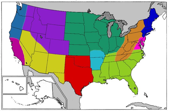
My whole-state map is displayed above. The regions I’ve included are the Northeast (dark blue), Appalachia/Pennsyltucky (orange), Mid-Atlantic (pink), Southeast (light green), Southern Plains (dark red), Ozarks (cyan), Desert Southwest (yellow), Californian Socialist Republic (magenta), Pacific Northwest (blue), Rocky Mountains (purple), and last but certainly not least, the Midwest (teal).

Above is a regional map of the US, where I didn’t restrict myself with state boundaries.

This is yet another regional map I did where I divvied the country up into 15 regions, where I added the Ohio Valley (lighter red), Southern Florida (grayish green), the Central Plains (bright orange) and the Northern Plains (bright yellow).
I’ll be adding links to other people’s maps here as I’m made aware of them and given links to them, so check back at this space to see how other people defined the regions!
Adam Moyer: Whole State regional map. Partial State regional map.
Chris Allen: Blog post.
Jacob Haqq-Misra: Blog post.
Jeff Frame: Whole State regional map.
Others: Coming soon?
If any of the rest of you would like to join in on this adventure, you can download a blank .jpg map of the US here. Then once you fill it out and stick it somewhere that’s accessible from the internet, let me know and I’ll add your name to the list above! Aren’t arguments about geography fun? 🙂
And in case you were wondering, I was really only doing this stuff while waiting for codes to finish running, or for TecPlot to open various 2.5GB files. So I wasn’t being a total slacker. 😛
1 Nation – 11 Regions
This entry was posted in Uncategorized. Bookmark the permalink.

5 Responses to 1 Nation – 11 Regions