« Welcome to The White House | Main | 3-0 Starts »
September 13, 2007
Cars and Counties
As many of you know, I've been car-less for nigh two weeks now. The clutch pedal was all of a sudden starting to stick with rapidly increasing frequency, thus not allowing me to shift, which on a car with a manual transmission is kind of a big deal. So last Thursday I had it towed by Graham's Exxon (there's no way I would give Walk's my money if I could help it, just on principle) over to Ripka's, a very good repair shop that's done work on my car before. I still don't know yet when they estimate they'll have it fixed because they're waiting on a part, but they said on Tuesday they're going to be replacing my clutch master cylinder (whatever that is). Hopefully that doesn't cost too much, and hopefully that actually fixes the problem. And hopefully it happens soon, I'd like to have my 221,000-mile car back. Walking to Ghetto Weis to get a few groceries is far inferior and less desirable than driving across town to Wegmans, for instance. And being able to drive to church so I could practice piano before this weekend would be nice too.
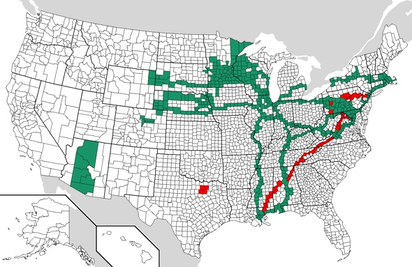
At any rate, all this car talk got me to thinking of where I've been this year. Last year I know that Chris posted at least one entry with a map of the counties nationwide that he's visited, so I filled in my own map (as did Jeff [Frame], at least, and maybe Jacob?), but didn't post it here. I've decided that it's high time that I post my own map though, so here it is:
The counties in teal are ones that I had been in prior to 2007 (airports don't count (otherwise I'd be able to add Atlanta and Los Angeles); I must have physically left airport property for it to count). The counties in red are counties that I was in for the first time ever this year. You can definitely make out the path that several interstate highways take, and interstates are how I've been able to color in a large percentage of those counties (maybe someday I'll actually figure out what the statistics really are, but I'm not Chris so I don't have them handy for all y'all). And most of the red counties came from just two trips -- my Katrina relief/missions trip to New Orleans back in March, and my trip to New York City to see the Twins-Yankees game in the Bronx at Yankee Stadium right before July 4th. And then there was also the Grad Resources leaders retreat in Dallas last month that I went too, which explains the island of red in Texas.
I know it's rather tedious, but if anyone out there wants to fill in their own map, you can get a blank county map here. Then if you want to post a link to your own in a comment, or if you'd like me to post yours here on my blog, send it to me! Seriously, it's a fun little task to do in your downtime if you have access either to a national road atlas or Mapquest (zoomed in to a proper level, it shows county boundaries). Nerdy, but fun. Trust me. :-)
Posted by Jared at September 13, 2007 12:04 AM
Comments
If you want to post mine at some point:
http://met.psu.edu/~frame/county_map.GIF
Posted by: Jeff at September 13, 2007 10:10 AM
you left rockland county NY blank. that's the mall you were in! YOU PEED THERE!
Posted by: caren at September 17, 2007 08:26 PM
I most certainly did! This is really making me wonder how accurate the rest of my map is, if I missed one like that. In my defense, it's really hard to see the county lines in urban areas on mapquest, and to match it up to a county on the map I supplied. Thanks for pointing that out, though!
Posted by: Jared at September 17, 2007 11:32 PM
